Wednesday, December 27, 2017

Coyote Mountain and Christmas in Anza Borrego

Coyote Mountain from the South
(click on photo to enlarge, exit back with x in top right )

We had planned a quick 4 day vacation in Borrego Springs when Kathy was working close to full time as giving child care to our grandson Zack. The money was paid for the campground and we were going to use our mini ten foot Carson trailer, while Zack was visiting the other grandparents in the Bay area.

Looking for fun things to do in the San Diego area, Afra had invited me to hike with some non Sierra Club groups with similar interests and no worries about rules and regulations. The go to book for these outing is "Hiking in Anza-Borrego Desert Vol 1 and 2" by Robin Halford. A few weeks ago one group did the Vista del Malpais hike and I really liked the loose format and low key people who were at the same time very competent.

Walking the rim of the badlands near Font's Point

The second group that Afra hikes with does a monthly hike. My first one with them was one of Halford's called Paul's Playa. It was also a great hike but taking a steep approach to the bumps in front of Coyote Mountain (from the Pegleg Mounument on the South side). It was a hard hike of about 6 hours. Jim had left a few hours early and was going to also climb Coyote. We waited for him at a high point rather late in the day, so the peak was not an option for the rest of us. I was a little disappointed, but it had been raining a bit and by the time we got back I knew it was the right decision. 

When we reached the campground, Kathy said she wanted to do something hard, like Villager.  I suggested that we do Coyote Mountain, from Rockhouse Road by the Clark's Dry Lake on the East side of the mountain. Although short (5.6 miles round trip) it is rated very strenuous by Halford. Since Paul's Playa was rated strenuous, I knew this was going to be a challenge. There was little surprise on my part when Kathy was all for it.  It was in the mid thirties that night, so we left a little after 8 and left the truck about 9. 

Through the flood plain to the start of the ridge network

We had a few false starts until the All Trails app helped us get on the right ridge. It is further North than your instincts might discern. Kathy and I have had practice at heated discussions and there was no way I was going to be too assertive and be headed back to camp early.

On the ridge at last and getting somewhere

The going was hardest at the beginning and toward the top

Kathy and I had started this hike with minor foot problems. I was recovering from a stone bruise on my heel from the Paul's Playa hike and Kathy had a toenail that was digging into her toe. As the day progressed, the rough terrain began to play on these weaknesses. The false summits were a bit hard on the optimism that we shared. The only thing that kept me going was I knew that there was way too much investment to turn around. It was not a safety issue on the foot problems for me, just a strong desire to make to the top and get going back down. We were probably hungry, it had been long time since breakfast. We shared a Laura Bar and kept putting one foot in front of the other. The top section  has a lot of chollas and the wind has done a good job of littering the surfaced with the little buggers.  The route going up is hard to see because of the steepness of the terrain. 

Finally, we reached the summit plateau. The view towards the badlands with Clark Lake in foreground

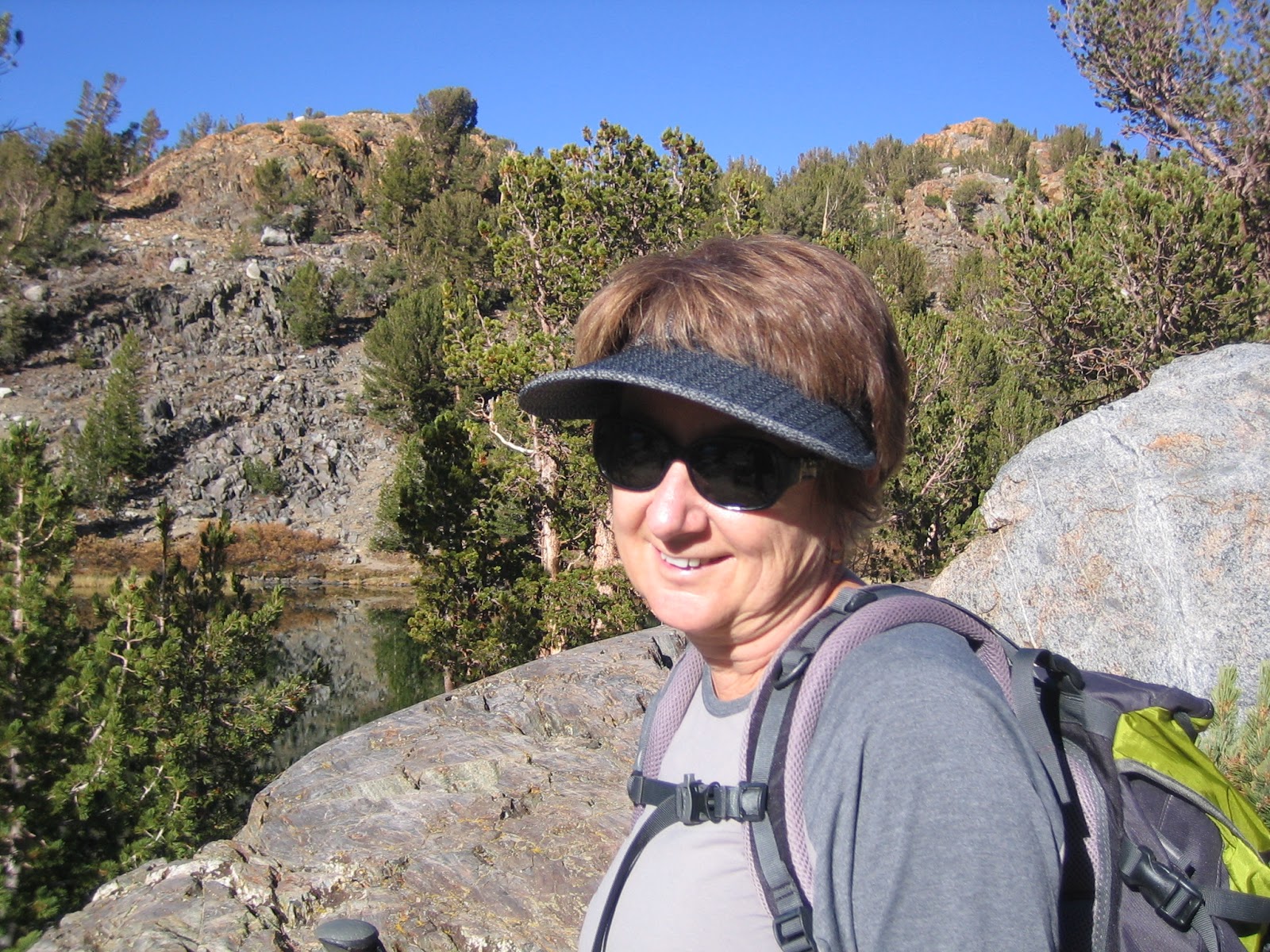
Kathy on top, looking a little more towards the South

We signed the register book and had a nice lunch. The whole hike was unusual in that the wind never picked up and the temperature never reached 70. A perfect day for an adventure where we weren't sure of a positive outcome.  On way down it was much easier to see a defined use trail, a bit more to the North from how we came up. The down climb was much easier than expected on the slippery small scree like conditions when using a side step. However, the new Montrail trail runners I got to overcome last week's heel problems still seem a little too lightweight. They work great in the Sierra on real trails, but in the point to point steep desert conditions, not so much. By the time we got back to the truck, my heel bruise was much worse, but we had plenty of medicine back at the trailer to make things right.

Stats: 2600 feet elevation gain and 5.6 miles round trip
rated very strenuous by Robin Halford

We rode bikes the next day on the Peg Leg loop and admired Anza's Angel on our now favorite mountain. By coincidence, we were riding on December 24, the same day in 1775 that the "angel" was seen and supposedly used to find the way to the coast. More likely they used a Native American to guide them as they were quite familiar with the route.The following day I rode my bike again because of hobble issues and Kathy hiked the Palm Canyon. No mountain sheep sited, just foreign tourists.


Wednesday, December 6, 2017

Three Passes in 3 days and the Sky Rock

Kathy had a reminder from two years ago on a post that I did on Bow Willow, a favorite camping place in the Anza Borrego desert. She gently spoke of my writer's block since then. Actually, it wasn't my last post. I did one on Denny, which was used as the eulogy at his funeral. Kathy thinks my concern with Denny's loss ( and Jon not too long before) was more to do with my own concerns with mortality and there is probably some truth to that. In any case, our recent trip to the Eastern Sierra seems like a good topic to get back on the horse and get on with things. Winter is coming.


We were staying at the Elm's Motel in Bishop. It is off the main street and next to a park, very quiet but a bit dated. Each day we would partake of the Spartan continental breakfast early and get a good start on the day's hike. The first pass would be the hardest, Bishop Pass. It usually is a menage of hikers, climbers, fisher folk and others that resist easy classification. The late November uncertain and colder weather thins out the crowd, so it was a perfect clear day which provided the stage for our adventure. At the parking lot the temperature was 30 degrees and we were the only car in the lot. I was thinking that maybe the locals knew something we didn't, but we packed up and headed up the trail.

  View from tarn towards Bishop Pass

South Lake is full, whereas last year the water didn't even reach the dam. It was a great water year for the Sierra. As we hiked in the shadows it was cold, but felt perfect in the early morning sun. It feels so good to be doing something with Kathy that we both enjoy. She has been on an extreme child care schedule, rising at 4 am and getting home at  7 pm. Tyler's mother is visiting this week and so we are free! There are no people ahead of us and I am starting to get acclimated to the altitude and beauty.

My favorite hiking companion

There are a lot of "step up" rocks on the Bishop Pass trail. With a full snow load, route finding is an issue. Today, there are patches of snow, but mostly the trail is bare. The cool weather allows us to make good time and Kathy is very fast and strong. At about 10,500 feet, I am starting to get stronger. In years past, things were different. Like many other facets of life, looking too much in the rear view doesn't help.

   Long Lake toward Bishop Pass

  Looking back toward South Lake

At about the four hour mark it was obvious that the summit block had snow. The trail has been expertly laid out and somehow the drifts never quite cover the short switchbacks that make the difference between easy hiking and something more serious. There is plenty of exposure and with careful footwork the patches of ice can be avoided. It's windy going up the head wall, so we stop in a protected place to eat lunch. It turns out it was less windy on top at the pass, where there were a couple of snow fields to be negotiated. After the obligatory summit photos, we head back down. The views are very spectacular on the way down and we are very happy with having made the hardest pass on the first day.

   Kathy almost at Bishop Pass

We remind each other to be careful on the down steps, as we haven't seen anyone on the trail and a turned ankle or some other lack of concentration would be a bad thing. Cell phones don't work up here and so you can't call your way out of a mistake. At the eight hour point we have made it back to the car without having seen anyone else on the hike. What a gift and adventure.


It's nice getting back to a motel room with a nice heater. Also, in a change of season trip the extra room from our bare bones trailer is much appreciated. We have room to keep the packs pretty much out of the way and ready to go for the next day. It's also a treat to get some Pollo Loco salads for dinner and enjoy some wine while talking back to the TV news.


Our second hike is an easy one to Morgan Pass. It is in the Rock Creek Canyon, also known as Little Lakes Valley. The parking lot is at 10,000 feet and the trail roughly follows the series of lakes that lead up the top lake (Chickenfoot) and then to the pass. Because the trail has numerous water crossing, it is a big help to have most of it free of snow. The parking lot was again 30 degrees, but the trail can feel colder because of the proximity of water.

       At Long Lake with Morgan Pass off to left of frame

I had bought some Bandini gloves, made for the cold Laguna mountain bike rides. I saw that Kathy had some lighter weight gloves, so decided to man up and use a similar pair. Within twenty minutes this decision seemed foolish as my hands were aching. Note to self: Kathy is 15 years younger and has better circulation in the extremities. Next time, be smarter about taking the right gloves. Being in the Sierra above 10,000 feet slows down the efficiency of the central nervous system and one needs to deal with the reality rather than how you feel things should be.

            Looking back toward Little Lakes Valley almost to Morgan Pass

Once we get out of the shade and the sun starts to creep above the mountain scarp, we start taking off layers and enjoying the fantastic views. Because we didn't get in a Sierra backpack this year, it is great to be making good time and not really having any significant issues. We have microspikes in the pack, but after yesterday I don't think that they are going to be necessary. The patches of ice are small and by good footwork can be avoided. Little Lakes Valley is a hike that anyone can enjoy with reasonable care because the trail is obvious when not covered in snow and the elevation gain is very gradual. Consequently, it is one of the most used areas in the Southern Sierra.

    Mount Morgan from the pass

Morgan Pass is free of snow and we enjoy a nice lunch there. The down hike is much easier and faster than Bishop Pass because there is more of a gradual descent and less rock steps. This is a great cross country ski basin and they have a California Snow Park area at the bottom of the steep hill that leads up to Mosquito Flats, where our truck was parked. This means that with a $30 yearly pass, you are assured of a plowed road to that point. When there is no snow, you don't need a pass. It is more dangerous in the spring, when the solid winter pack starts to degrade and you can break through into a stream or lake. In the winter, you should check the avalanche forecast as in certain places the sides of the canyon are quite steep. The Rock Creek Winter Lodge is a few miles below Mosquito Flats and offers rustic cabins and great food.

Kathy's toes are starting to get a little worse for wear, but we want to do Mono Pass. The ranger didn't know the present conditions, but we can always turn back if things look dicey. I did Mono with a full snow load with my brother Marty on skis, but that was almost a lifetime ago. There is some beautiful above timberline scenery and looking forward to this adventure which is probably in between Bishop and Morgan Pass in difficulty.

     Kathy looking toward Morgan Pass from Mono trail

We leave the parking lot with the temperature again stuck at 30 degrees. I've got my heavy gloves on and after a mile or so we head off to the right at the Mono Pass signed trail. It is very south facing and becomes too warm very quickly. As we shed clothes and gain altitude, the whole basin comes into view and it is spectacular. The trail is the best of the week, with a nice, soft sand component that although steep, is never scary. Ruby lake, a favorite for back country skiers, comes into view beneath us and the long switchbacks get more steep.

     Above Ruby Lake on Mono Pass trail

 
Mono Pass


Finally, we get into the summit canyon and begin to pick our way through steep rock and giant boulders. It's a fun hike and we haven't had to deal with any snow or ice to this point. It looks like there will be some snow to negotiate at the pass proper, but even this is not necessary as there are many paths to the side of the blockage. No question we are at altitude as the place looks like a scene from some SF movie. As we get a little beyond the pass, Summit Lake comes into view. We decide to save looking down Pioneer Basin (which leads to the John Muir Trail) for our hike next year. On the way down the views are even better. It has been a great day.

          Summit Lake above the pass

   Kathy headed back to the truck

We have been trying to find Sky Rock, a native american petroglyph which is in a volcanic bluff section above the Owens River. We park the truck in a small turnout and gain the three or four hundred vertical to the site of a rather large collection of gigantic volcanic boulders. It probably stretches for close to a half mile, so just getting here is not finding the rock art. I work my way through a weakness in the bluff, but have really only succeeded in making communication with Kathy very difficult. She, on the other hand, it looking for a tell that involves one giant boulder leaning on another. Unless you were Superman, who can leap over buildings with one bound, it is no easy matter to survey things from the top, where I am. Don't really want to make any mistakes that might put me in the ER.

  Trail to the "Sky Rock", Mt Tom in background

I see some tracks and get within a few yards of the site, where I can see the moons of the composition. Not good form to get anywhere on the "canvas" as too much love has desecrated many of these sites. Kathy has found  the rock on her own and we find a way for her to get to my point safely. What a rush! This whole week has been a coming together again and I am so happy to be sharing this experience with Kathy.

    Sky Rock